Partner: Gisat s.r.o.
Field: geology, geodesy
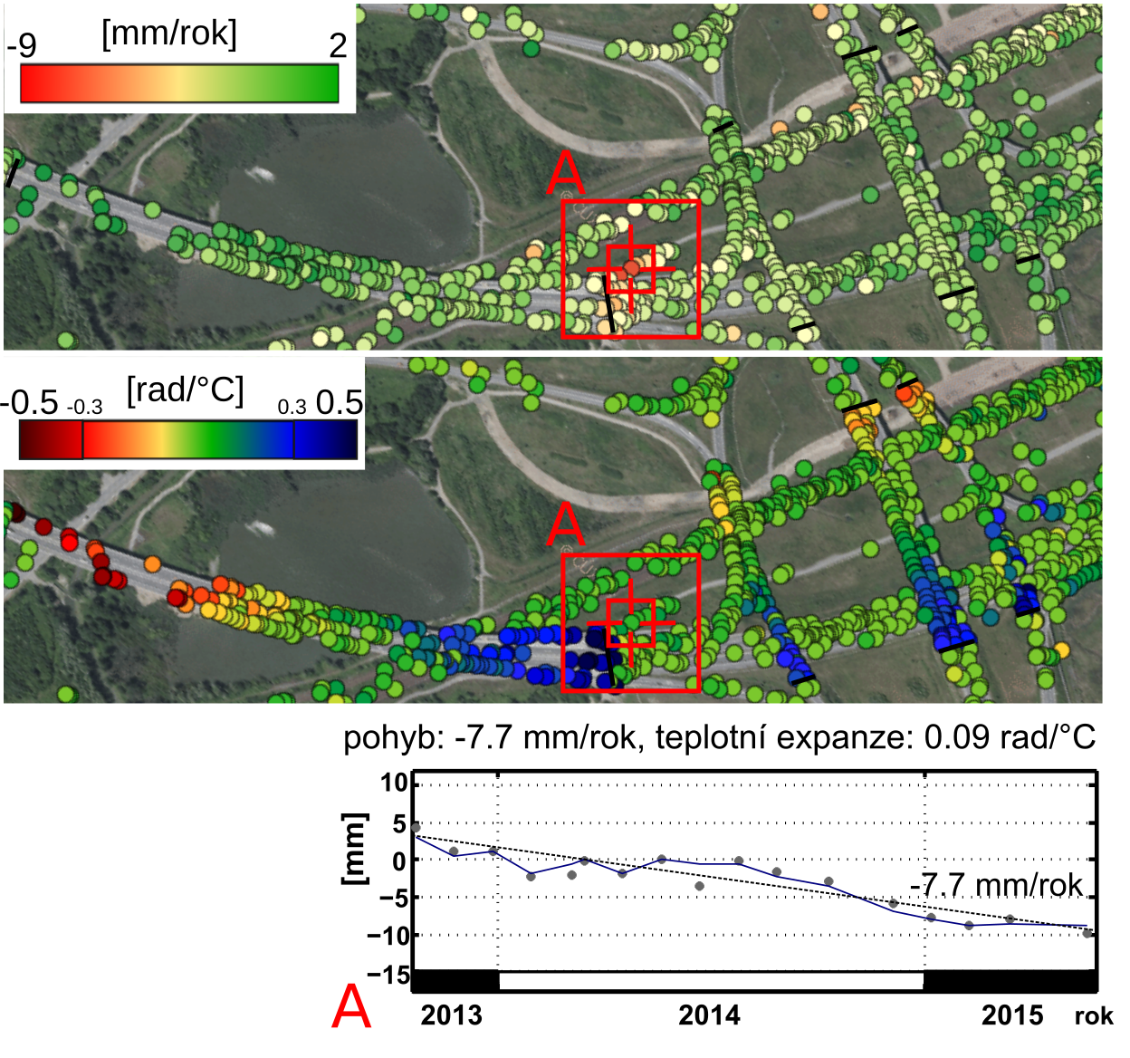
In cooperation with professional companies within a TACR (Technology Agency of the Czech Republic) project, we are involved in the development and application of algorithms for Interferometric Synthetic Aperture Radar (InSAR), which enables identification
of primarily vertical movement of built structures (buildings, bridges, etc.) with an accuracy often exceeding 1 mm/year. The sensitivity of synthetic
aperture radar (SAR) satellites to movement opens the door to their potential use for identification of terrain
changes, such as synclinal valley development in undermined areas, and detection of landslides.
Data generated by SAR satellites have already been available since the 1990s (Europe Sensing Satellites - ERS, resolution of 25x5 m, imaging every 35 days). The latest SAR satellites enable very high resolution (Cosmo or TerraSAR-X - standard resolution of 3x1 m, revisit
cycle of a few days; Sentinel-1 – resolution of 4x20 m, revisit cycle of 6 days), which is an advantage in continual scanning and open data access. For accurate
analysis, primarily the Persistent Scatterers method is used to process time series of at least 30 images. With
the increasing number of images, not only the accuracy of results but also storage and computational resource
requirements are increased.
Complex processing of a huge amount of radar image data using an HPC infrastructure is a question of several minutes while using a standard workstation these computations take several days. The IT4Innovations infrastructure provides computational resources enabling independent running of computations over various data sets or fields of interest. As each compute node is exclusively allocated, the collaborators can thus perform computations with a fast response and a graphical user interface without being limited by the overall utilization of the infrastructure. For performance of experiments, the commercial SARPROZ software and developed in-house codes have been used. Building on the experience gained from the previous cooperation, we have developed our own solution, namely the IT4SI application, which allows efficient use of HPC for InSAR processing of data generated by the Sentinel-1 satellite. This solution has been partially implemented into the Floreon+ platform for support of crisis management in the Czech Republic. The objective is to automate the demanding approach to processing so that the technology is applicable for experts with no deep knowledge of InSAR.
The project of the Technology Agency of the Czech Republic named “Monitoring of undesired movements and deformation of transport infrastructure using radar interferometry” was evaluated as the best one in its category for the 2018 TACR award.
PARTNER´S NOTE
Jan Kolomazník
Technical and project manager
GISAT s.r.o.
“Cooperation with IT4I within the project focused on detection of undesired transport infrastructure deformations via satellite data
has been very productive for us. Processing of long time series of satellite images using radar interferometry is computationally
intensive, and its deployment on HPC infrastructure has enabled us to significantly streamline and speed up the computing process.
Having no previous experience with deploying this technology, using the cloud services of IT4Innovations National Supercomputing Center, we have immensely appreciated the
support provided by the IT4I experts who assisted us in cluster configuration and in design of the computing solution as well as
of the processing scripts. Therefore, we look forward to building on our latest cooperation in the future.”