3D Modeling and Risk Assessment for Nuclear Facility Safety
Call: 32nd Open Access Grant Competition, OPEN-32-22
Researcher: Ivo Opršal
Institution: Czech Academy of Sciences
Research Area: Earth Sciences
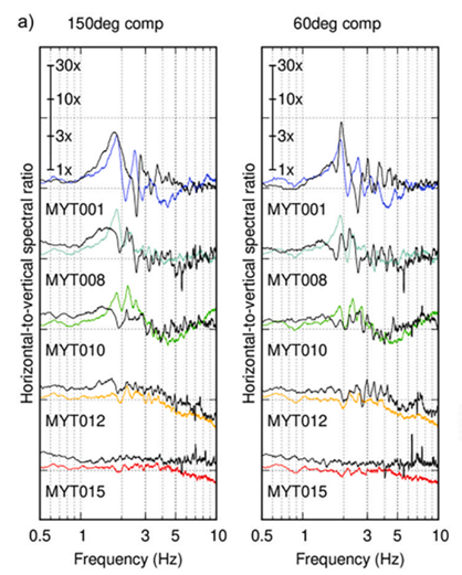
Fig.: Simulated and observed spectral amplification (here called HVRS ratios) in the near-surface geological structure of the Mýtina maar in western Bohemia. Black: Observed data for two rarely perpendicular horizontal components ("150deg" represents amplified mode 1 oscillation at a frequency of 1.83 Hz, "60deg" mode 2 at a frequency of 1.91 Hz). In colour: Synthetic seismograms modelled by the finite difference method (using IT4I). The amplification of waves at the MYT001 station is about 10 times. Modified from Labuta et al., 2025, Fig. 6 a
IT4Innovations supercomputers (Karolina, LUMI and Barbora) will help scientists at the Czech Academy of Sciences better understand seismic tremors that can threaten key infrastructure such as nuclear power plants, dams, power lines, and pipelines. The research will focus on evaluating and numerically modelling the local amplification of seismic tremors caused by the geological structure of the underlying bedrock and near-surface geological structures in basin areas of the Czech Republic considered for potential nuclear power plants.
This seismic amplification is one of the key factors affecting seismic risk. The project aims to develop an optimal methodology to assess this amplification and to investigate all seismotectonic risks. The results of the research will be combined with geological data and the conclusions of previous studies into a regional model allowing more accurate prediction of seismic tremors and analysis of other potential hazards. Wave propagation numerical modelling using advanced computational tools (IT4I) will play a crucial role specifically in simulating seismic scenarios leading to the evaluation of the impacts of geological conditions on the amplification of earthquakes. This approach will allow the evaluation of the wider social and economic impacts of earthquakes, which can endanger human lives but may also cause damage to critical infrastructure. This will enable more detailed analysis and effective planning for its protection.
Reference:
Labuta, M., Oprsal, I., Landa, D.-A., Burjánek, J., 2025. Ambient Vibrations of a Deep Maar Resonator. Soil Dynamics and Earthquake Engineering, 188, Part B, 2025, 109072. https://doi.org/10.1016/j.soildyn.2024.109072
Impact of urban surfaces on regional scale rain and cloud patterns
Call: 28th Open Access Grant Competition; OPEN-28-9
Researcher: Peter Huszár
Institution: Charles University in Prague
Field: Earth Sciences
It is well known that the earth's surface significantly impacts weather and climate, i.e., it matters whether the surface consists of forests, fields, water, or built-up areas. In this respect, urban sprawl has an unquestionable impact.
The impact of urban sprawl on essential meteorological variables such as temperature (the well-known urban heat island phenomenon) and the wind is well-mapped. However, the effect on water vapour and its transport and circulation, i.e., cloud formation and precipitation, is still poorly understood. There are indications that cities can alter the direction of movement, intensity, and overall life cycle of storm clouds. However, the long-term climatological impact of storm clouds is unknown.
The project is aimed at quantifying the long-term impact of urban areas. Using a regional climate model (WRF) applied over Central Europe for a 10-year period (2008-2017), it aims to calculate the average impact on variables such as humidity, cloud cover, rainfall intensity, etc. The research follows a long-term research focus of the Department of Atmospheric Physics, Faculty of Mathematics and Physics of Charles University, on assessing the overall impact of urban areas on the atmosphere. The research at the Department is led by the principal investigator of this project.
Climate variability and atmosphere-glacier interaction on James Ross Island, Antarctica
Call: 27th Open Access Grant Competition; OPEN-27-14
Researcher: Michael Matějka
Institution: Masaryk University
Field: Earth Sciences
Earth´s polar regions have been one of the most affected by recent climate change. Accelerated glacier melt, sea ice extent reduction, and changes in snow cover dynamics are among the most prominent impacts. Consequently, sensitive polar ecosystems are forced to adapt themselves to changing conditions.
The main goal of our project is to run a simulation of the climate in the Antarctic Peninsula region in the period 2000–2100. This area, where also the J. G. Mendel Czech Antarctic Station is located on James Ross Island, is characteristic of the glaciers' extremely high sensitivity to predicted air temperature changes.
The climate evolution will be simulated in a high spatial resolution by the WRF model. This allows better representation of local complex topography on the climate compared to available global models output. A smaller part of the available computational resources will be used for a very detailed simulation of meteorological conditions and snow cover processes in the study area.
PALM simulations for the project TURBAN
Call: 26th Open Access Grant Competition; OPEN-26-32
Researcher: Jaroslav Resler
Institution: the Insitute of Computer Science of the Czech Academy of Sciences
Field: Earth Sciences
The OPEN-26-32 project is supported by the international TURBAN (Norwegian Funds, www.project-turban.eu) research project, which deals with air quality and thermal comfort in cities. Within the project, we are working on the development and refinement of the PALM model, which can simulate processes at the urban canyon level, and its application in practice. The PALM model is based on the principle of large eddy simulation (LES). LES models can provide detailed information about the airflow, including the turbulent component ("eddies"), at high spatial resolution, which is computationally demanding. In order to validate the model under realistic conditions, a network of measurement sensors, a microwave radiometer, and a Doppler LIDAR was commissioned in the centre of Prague in 2022. In this project, we are also exploring ways to combine model outputs, acquired measurements, satellite imagery, and results from simpler models. Thanks to IT4I, we have obtained enough computational resources on the Karolina supercomputer to cover a significant part of the simulations planned for the TURBAN project.
Applications of Deep Neural Network based Urban Change Detection using Remote Sensing
Call: 25th Open Access Grant Competition; OPEN-25-24
Researcher: Georg Zitzlsberger
Institution: IT4Innovations
Field: Earth Sciences
Remote sensing describes the observation of events from distance, like satellites orbiting around earth, used to image the earth surface. This can happen in different ways, like taking multispectral images or using radar.
The former is a sophisticated digital camera that also captures the non-visible light spectrum, like infra-red or ultra-violet. The latter, called Synthetic Aperture Radar (SAR), does not need sunlight to illuminate the scene but emits a radar signal and detects its reflection which works at high resolutions and also during darkness.
In our research, we combine both observations together, using different satellites, like ERS-1/2 & Landsat 5 TM (1991-2011), or Sentinel 1 & 2 (2017-today). In combination with a deep neural network (artificial neural network), we identify urban changes, i.e. construction/destruction of buildings or roads. In our work, we use almost all observations available to enable a constant and automatic monitoring of cities or rural areas.
Harvesting seismic waveform data for microseismicity with deep learning approaches
Call: 24th Open Access Grant Competition; OPEN-24-76
Researcher: Christian Sippl
Institution: the Czech Academy of Sciences
Field: Earth Sciences
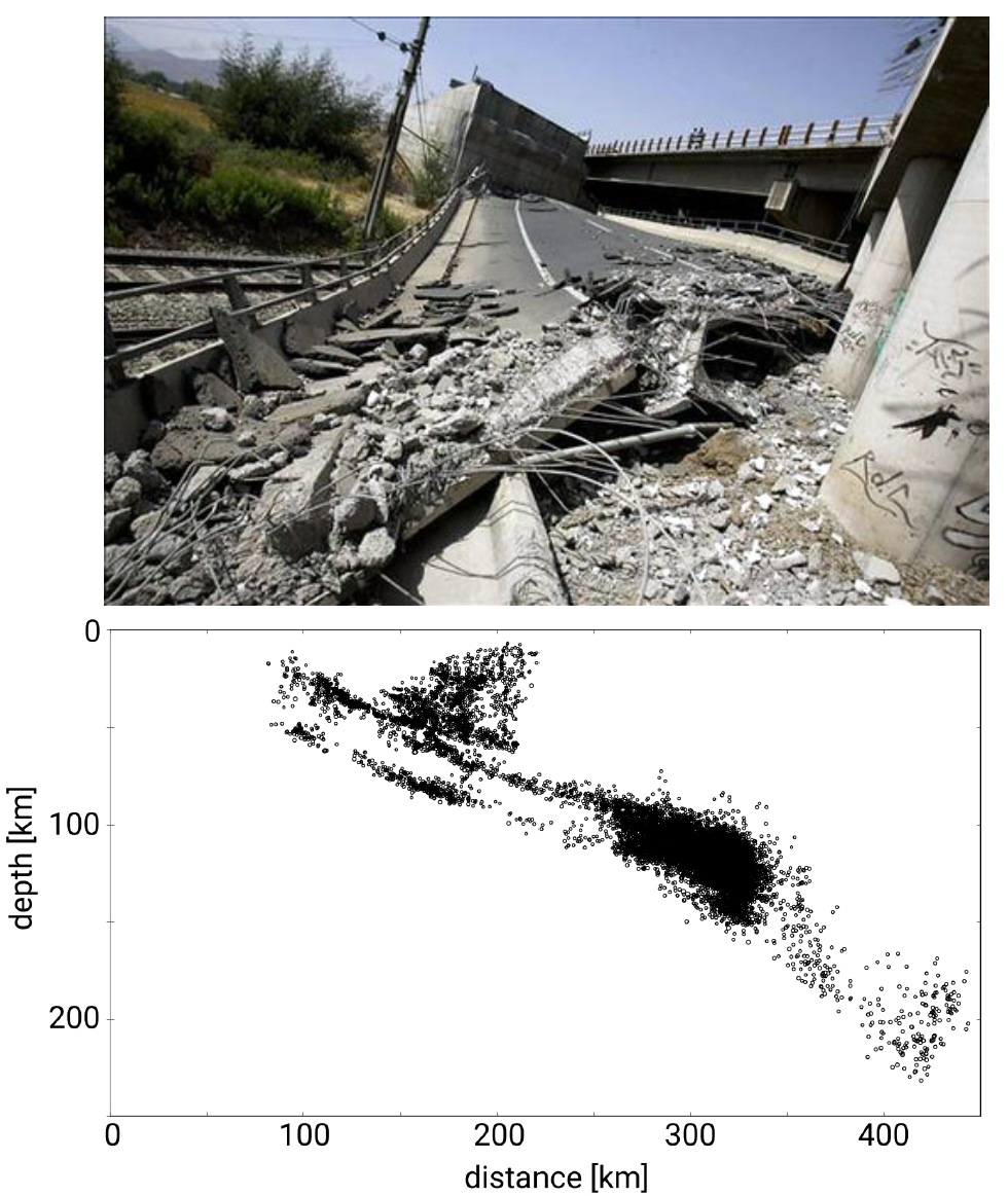
The largest earthquakes on the planet occur in subduction zones, where one tectonic plate of the earth moves under another. Instead of directly investigating these irregular big events, we study the thousands to 100,000s of microearthquakes that occur in these regions every year. Most of them are too small to be felt. The patterns and mechanisms of these small events contain information about the stress conditions of the region. They can constrain the likelihood and spatial extent (but not timing) of future large earthquakes.
Given the huge number of small earthquakes in the investigated areas (>10,000 per year in the north of Chile, South America, alone) and the big amounts of available seismic data (10s of TB), processing such events “by hand” is not feasible. In the present project, we train computers to detect and locate such small earthquakes by applying deep learning algorithms.
THERMOCHEMICALLY-DRIVEN CONVECTION AND DYNAMOS OPERATING AT LOW EKMAN NUMBERS
Call: 21st Open Access Grant Competition
Researcher: Dr Ján Šimkanin
Institution: Institute of Geophysics of the Czech Academy of Sciences
Field: Earth Sciences
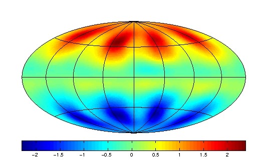
The Earth's magnetic field is one of the most variable geophysical fields. It provides us with effective protection from solar flares and is a useful navigation tool not only for us humans but also for animals. The Earth's magnetic field is generated by convective motions of electrically conductive melt in the Earth's outer core and penetrates the Earth's surface, where it is observed as a large-scale, dipole-dominated field. These generation processes are called Geodynamo for short. However, we have no direct information about the magnetic field in the Earth's core, and for this reason we model the magnetohydrodynamic processes in the Earth's outer core numerically. Geodynamo's numerical models produce magnetic fields that are close to the observed geomagnetic field. We are also able to reproduce its temporal variations, be it short or long term (called secular variations). However, we cannot use parameters typical of the Earth's core in our models for computational reasons – so far there has been no supercomputer in the world that can solve a Geodynamo model with such values. Nevertheless, we are gradually approaching these values, and one of the approximations is to model thermochemical convection and thermochemically driven hydromagnetic dynamo at low fluid viscosity.
COMPUTATIONAL MODELLING OF FAST ION ORBITS IN TOKAMAK
Call: 19th Open Access Grant Competition
Researcher: Dr Fabien Jaulmes
Institution: Institute of Plasma Physics of the Czech Academy of Sciences
Field: Earth Sciences
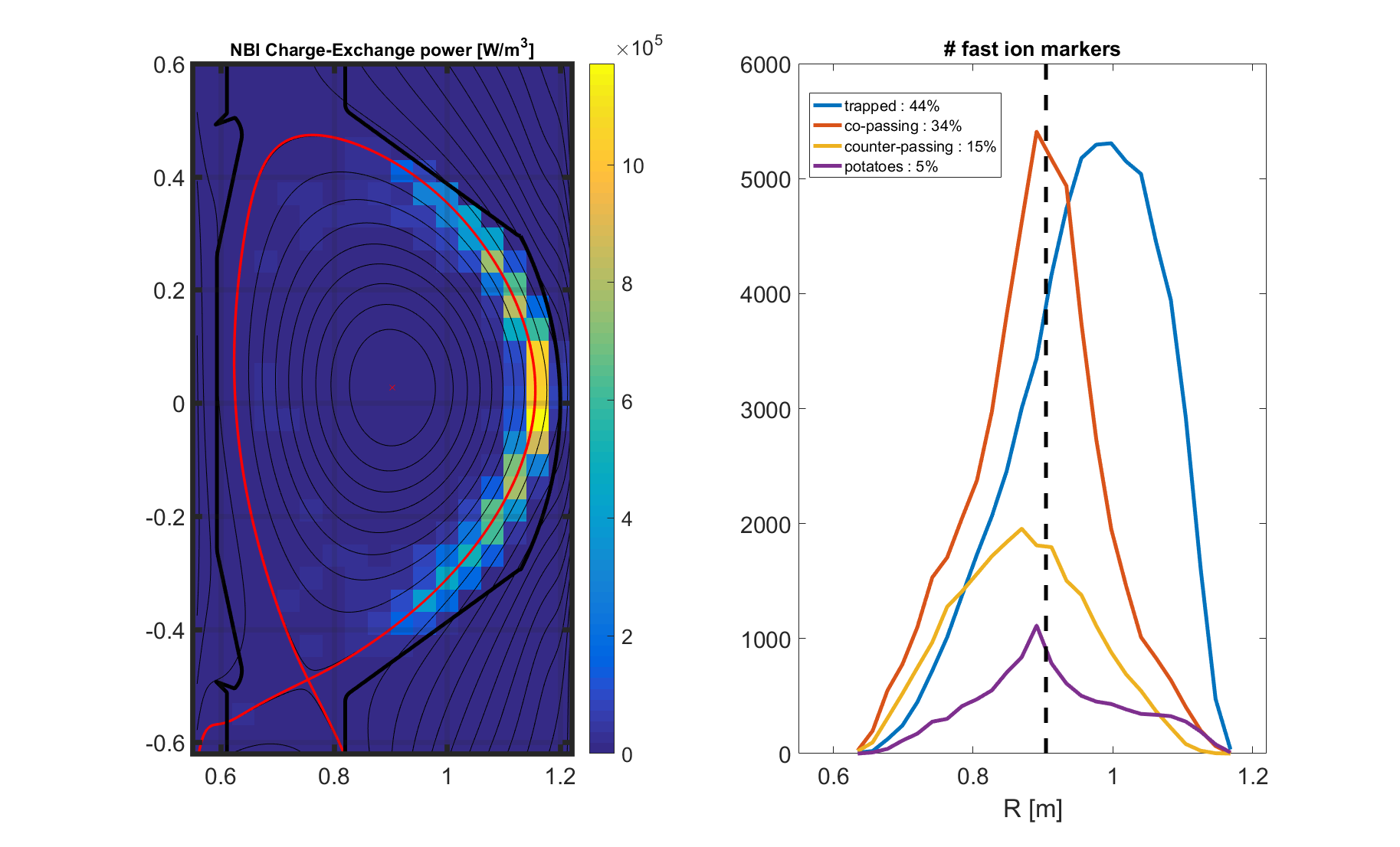
Nuclear fusion technology might enable us to generate energy without releasing large amounts of greenhouse gases into the atmosphere or leaving behind us long lived radioactive waste. Among the approaches to fusion, tokamak seems to be the most promising one. The concept involves the use of magnetic fields to confine plasma hot enough to sustain fusion within itself. Within the international ITER project, a new tokamak is being built in Southern France. If successful, the device would be the first one of its kind to produce net energy. COMPASS is a small tokamak located in Prague, Czech Republic. It allows scientific investigation of various physics issues related to the operation of the future ITER. Fabien Jaulmes and his team was awarded more than 1.7 million core hours for his project focused on the study and modelling of narrow band imaging-born particle (NBI) behaviour, which might have impact on the future design of the system and its integration in COMPASS as wel as in the planned upgrade of the machine in 2022. The project aims at achieving better scientific understanding of tokamak nuclear power stations as well as cheaper and more sustainable power generation on larger scale. Having high potential impact on future reactor maintenance costs, this study aims to optimise heating systems.
RUPTURE PARAMETERS OF DYNAMIC SOURCE MODELS COMPATIBLE WITH EMPIRICAL GROUND MOTIONS
Call: 19th Open Access Grant Competition
Researcher: Dr Lubica Valentova
Institution: Faculty of Mathematics and Physics, Charles University in Prague
Field: Earth Sciences
Within the project awarded 481 000 core hours, the seismology team from the Department of Geophysics at the Faculty of Mathematics and Physics of Charles University in Prague will focus on the study of earthquake source model parameters that control the rupture propagation process on a fault. Based on the random sampling method, they will generate a large number of rupture propagation simulations (up to several ten thousand). However, not all such synthetic earthquakes correspond to real phenomena. Therefore, statistically, only those simulations that generate strong ground motions agreeing with observations from a large number of real earthquakes, i.e. an empirical model, are accepted into the database. The result will take the form of a large database of earthquake scenarios (several thousand) with varying magnitudes and varying complexities of rupture propagation. These phenomena arise from the determined laws of physics for processes at the fault, while at the same time arousing realistic ground movements. Due to the complexity of this synthetic database and lack of observation errors, characteristics such as rupture duration, size of the ruptured area, stress drop, and energy budget are compared with their real counterparts determined from actual phenomena in further analysis. The key focus in this project includes the study of obtained parameters acting in the friction law (their variance and potential correlations), which are not generally accessible for real events and which have significant impact on the resulting ground motions. Thus, studying a seismic source using numerical simulations may also be useful for assessing the effects of earthquakes and seismic hazards.
SIMULATION OF PROBE DIAGNOSTICS FOR COMPASS-UPGRADE
Call: 18th Open Access Grant Competition
Researcher: Dr Aleš Podolník.
Institution: Institute of Plasma Physics of the CAS
Field: Earth Sciences
Aleš Podolník was awarded more than 1 million core hours for simulation of probe diagnostics for the COMPASS-U tokamak, a world-class fusion research facility which is currently being designed and constructed. This device shall produce plasmas relevant to those ones in the future ITER and DEMO fusion reactors. One of the planned areas of research is also to design plasma facing components, which require complex diagnostics equipment. To study the unique plasma properties in the COMPASS-U tokamak, both the existing and the newly-developed diagnostics systems will be used. One such diagnostic is Langmuir probes which, when properly set up, can measure electron temperature and density essential for calculation of thermal stresses of the plasma facing components. However, design and use of probes for measurements inside the tokamak with extreme plasma parameters takes significant effort. The research project of Aleš Podolník and Michael Komm aims at simulation of probes that would be accommodated to various variants as well as shaping options of plasma facing components inside the tokamak. Previous research projects show that proper probe design is crucial not only from the operational point of view, for example, to avoid melting of the probe under extreme plasma energy flow, but also to maximize the accuracy and precision of obtained physical data, in particular.
ELECTRIFICATION OF THUNDERSTORMS SIMULATIONS OF SELECTED EVENTS
Call: 17th Open Access Grant Competition
Researcher: Dr Zbyněk Sokol
Institution: Institute of Atmospheric Physics C
Field: Earth Sciences
More than 1 million core hours was awarded to Zbyněk Sokol from the Institute of Atmospheric Physics CAS for simulation and study of electrification of thunderstorms. Thunderstorms are one of the most dangerous climate phenomena, which are accompanied with strong gusts of wind, hail, and high lightning activity. Although they can lead to huge socio-economic losses related to severe material damages as well casualties, thunderstorms have not been fully described and understood yet, which makes their prediction uncertain. One of the processes in thunderstorms that remain unclear is the process of electrification. Zbyněk Sokol, together with his colleague Jana Minářová, will use the supercomputer to simulate the electrification process during convective thunderstorms which were observed within the territory of the Czech Republic between 2018 and 2019. These simulations will take place using the Cloud Electrification Model (CEM), which has been implemented in the COSMO Numerical Weather Prediction model, or CEM-COSMO. The authors consider their project innovative as it is the first time that electrification of thunderstorms will be studied over the territory of Central Europe. The project results may lead to expanding the knowledge related to thunderstorms, such as electrification and lightning activity, as well as more accurate weather forecast modelling.
VALIDATION OF THE MODEL PALM-4U AGAINST OBSERVATION CAMPAIGN IN PRAGUE-DEJVICE
Call: 15th Open Access Grant Competition
Researcher: Ondřej Vlček
Institution: The Czech Hydrometeorological Institute
Field: Earth Sciences
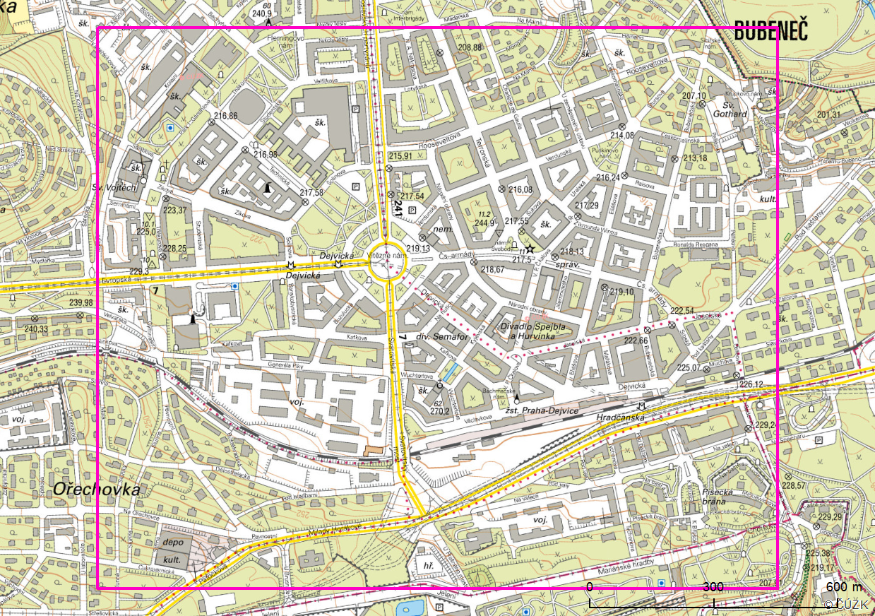
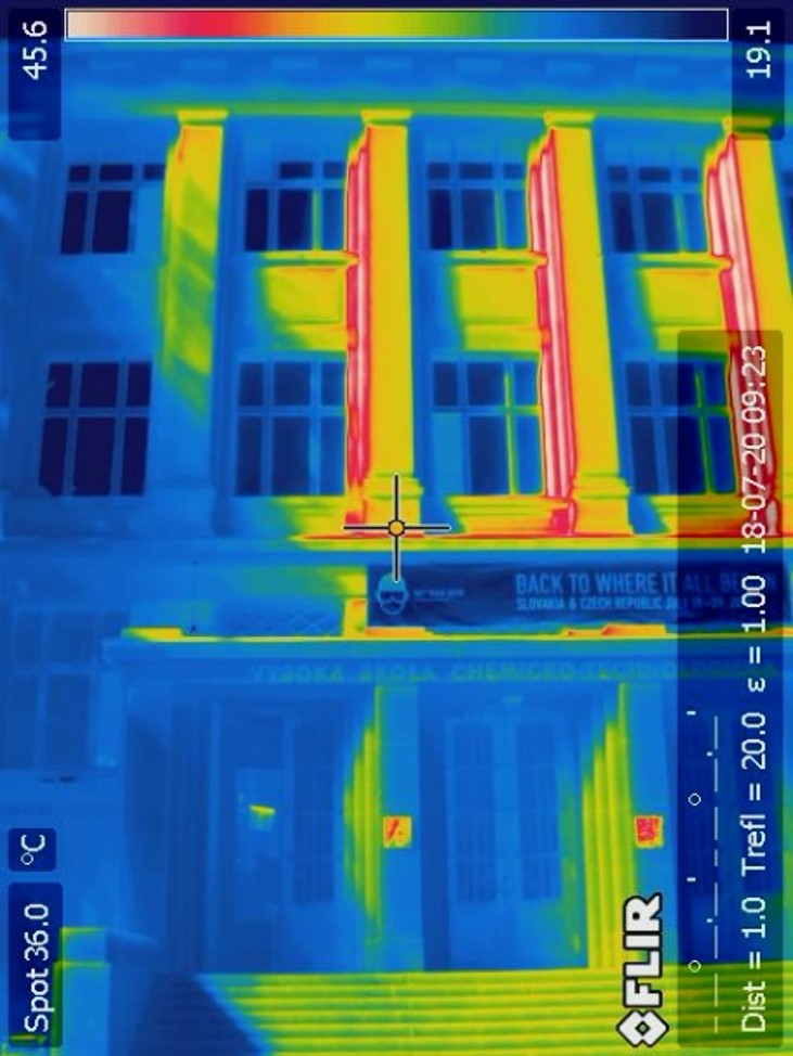
PALM-4U (www.palm4u.org) is a micro-scale model which allows detailed simulation of meteorological conditions and air quality in urban areas with a resolution of single meters. Its use makes modelling of increasingly frequent extremely high temperatures in urban areas (Urban Heat Island Effect) followed by increased air pollution easier. Besides, the model also allows complex evaluation of urban scenarios’ impacts on microclimate and air quality. The project of Ondřej Vlček from the Czech Hydrometeorological Institute (CHMI) and his colleagues from Charles University and the Czech Academy of Sciences aims at carrying out detailed validation of the latest PALM-4U model against the observation campaigns done in the Praha-Dejvice area. The campaign measurements were conducted by CHMI specialists in two fourteen-day episodes with one taking place in the summer and the other one in the winter of 2018. They measured not only the meteorological conditions and air quality in street canyons, but also building surface temperatures and heat flow through facades using infrared cameras. The team will also have access to the data generated by Prague’s meteorological stations. For validation of the model, they closely collaborate with partners from the German MOSAIK project (Urban planning based on the model and its use in the climate change domain), and they were awarded more than 1 million core hours for this work within our 15th Open Access Grant Competition.
CONVECTION PERMITTING CLIMATE SIMULATIONS
Call: 14th Open Access Grant Competition
Researcher: Dr. Michal Belda
Institution: Charles University
Field: Earth Sciences
In climate change assessment, global and regional climate models are an important tool. However, they still have relatively low resolution, and their potential to be used for local application is therefore limited. The low resolution of the majority of models does not allow implicit assessment of phenomena such as upward movements (convection) and the resulting intensive precipitations. In models, these phenomena need to be parametrically represented. Since 2016, researchers from almost 30 European institutions have been cooperating on a pilot study approved by the advisory team of the World Climate Research Programme (WCRP). For developing climate scenarios, this study uses regional nonhydrostatic high-definition (3 km and less) implicit convection permitting modelling. In the future, we will thus have much more detailed scenarios of climate change effects on the regional and local level. In our 14th Open Access Grant Competition, Michal Belda from Charles University, who is involved in this WCRP pilot study, was awarded 1 million core hours for the simulation of long-term climate in the past in order to serve as a base for assessment of future climate scenarios. Belda will focus on the Alpine region and the Czech Republic.
PARALLELIZED REACTION-TRANSPORT MODEL OF CONTAMINATION SPREAD IN GROUNDWATER
Call: 13th Open Access Grant Competition
Researcher: Dr Michal Podhorányi
Institution: IT4Innovations
Field: Earth Sciences
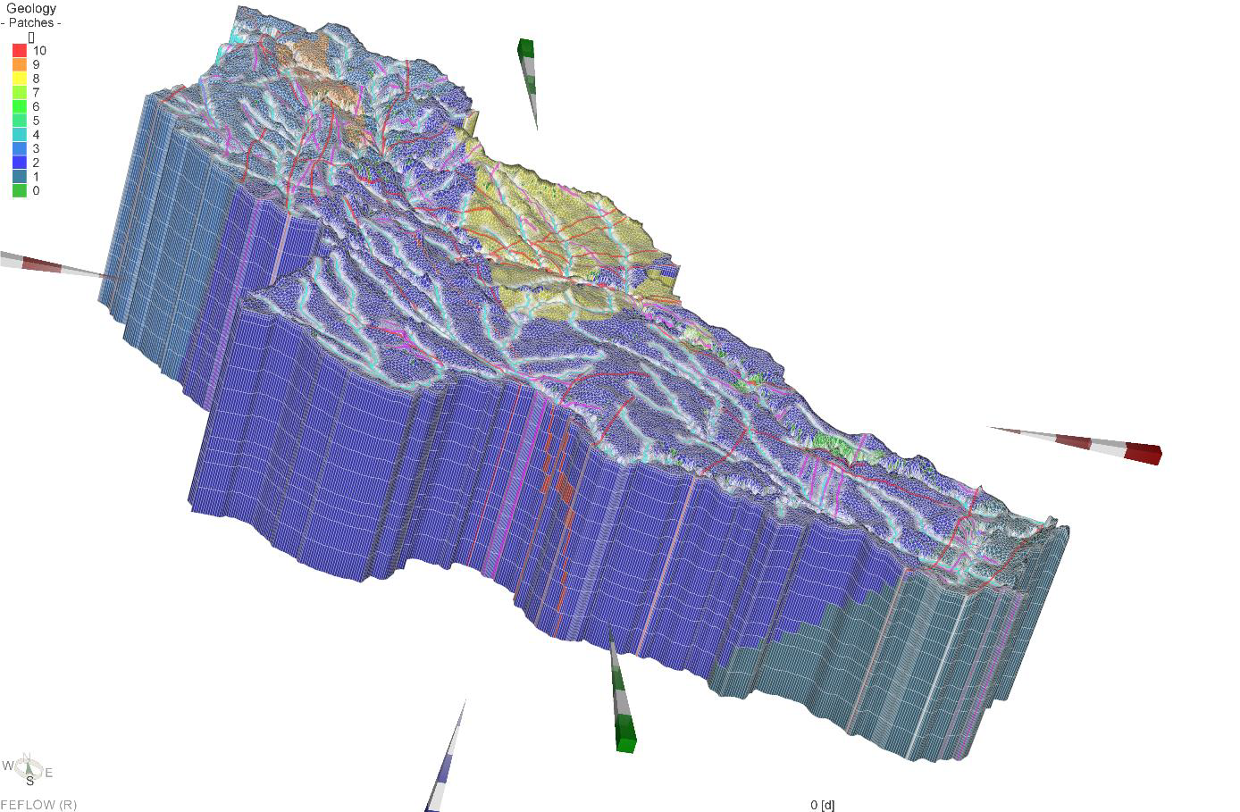
Radioactive waste (RAW) emits hazardous radiation even for tens of thousands of years. Therefore, it must be isolated from the environment for a long time until it turns into stable substances. In the Czech Republic, RAW is safely stored in three radioactive waste repositories. However, the globally most efficient and safest way for the disposal of these substances is considered to be a deep repository in a stable geological environment with the absence of natural disaster hazards, such as earthquakes and floods. In the Czech Republic, the Czech Radioactive Waste Repository Authority is responsible for the deep repository project, which is to be commenced in 2065. The Authority is currently identifying potentially suitable locations, and the final location is supposed to be selected in 2025. Our colleagues Michal Podhorányi and Lukáš Vojáček have been cooperating with Masaryk University in Brno and the DHI company in the project titled Parallelized reaction-transport model of contamination spread in groundwater (PaReTran) supported by the Technology Agency of the Czech Republic (TH02030840). The objective of the PaReTran project is to improve methods of analyses of the potential risk of environmental contamination due to long-term spread of radioactive substances from the deep radioactive waste repository through the surrounding rock formation. Since simulations generated using reaction-transport models (FEFLOW) are computationally intensive, their parallelization for deployment on HPC systems will allow their speed-up. The computational resources awarded in our 13th Open Access Grant Competition will be used by the researchers for the TRM program development. They will focus on testing and evaluating the scalability of the program parallelization using the open-source PhreeqcRM library for simulations of geochemical processes.